Transportation
Vision
Newmarket will be a vibrant community where development and multi-modal transportation infrastructure are planned together. Our evolving downtown and rural streetscape will encourage residents and visitors of all ages and abilities to walk and bike throughout town. Walking, biking, driving, and community transportation will feel like safe and convenient choices. Trails and walking routes will strengthen community bonds by interconnecting with neighborhoods and green spaces. Meanwhile, streets will be designed purposefully for all modes of travel in accordance with their geographic context to create a sense of place, improve safety, and facilitate travel. Ultimately, Newmarket residents will have more options on how to travel throughout town and will be able effortlessly to connect with neighboring municipalities and regional transportation hubs.
Vibrancy
A vibrant community is one that exudes energy and is full of activity and life. It is welcoming and friendly to all ages, supports cultural diversity, and provides economic opportunities.
Vibrancy is measured by how well humans interact with their physical and social environments. A transportation network in good condition that is safe to travel by multiple modes (driving, walking, biking, taking public transit, etc.) is essential for vibrancy. Newmarket’s current village core is the epicenter of its vibrancy – historic buildings along well-lit streets that encourage safe vehicle speeds, wide sidewalks with trees, wide crosswalks with pedestrian-activated signals, space for socializing and outdoor dining. Those street design features should be replicated as the village core expands along North Main St (NH108), South Main St (NH152), and Exeter Rd (NH108). These state routes act as primary entry and exit corridors and draw most traffic to the village core.
Maintaining Newmarket’s vibrancy will require a street network that is organized and designed to accommodate as many types of users as possible. This idea is embodied in the concept of “complete streets”. A complete streets approach considers context: a downtown main street, a rural two-lane highway, and a neighborhood street should all be shaped by different design considerations that accommodate and safeguard the abutting land uses. Accessibility must be a primary consideration as new streets are designed or slated for improvement throughout Town. See Appendix C for more information about complete streets design.
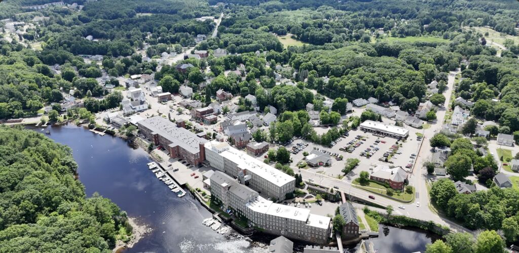
Vibrancy in the downtown core depends on a streetscape that is inviting to pedestrians with parking that is well signed and easily accessible. Comprehensive wayfinding signage should be developed to guide residents and visitors through town and to the village core, identify important routes, and designate specific sites like parking, attractions, trails, parks, and municipal facilities. The design should also require careful consideration of parking, as many survey respondents to the 2024 Master Plan survey stated that a lack of vehicle parking was the primary challenge to starting a business in Newmarket. With the increasing adoption of electric vehicles, Newmarket should also consider capacity for public electric vehicle charging when planning parking improvements. Strafford Regional Planning Commission conducted a parking study in Newmarket in 2025 that included a set of recommendations for improving parking and access to the village core. See Appendix C for a summary of findings.
Electric “micromobility” is a transportation technology quickly gaining popularity across the country. Small electric mobility devices such as electric bicycles and scooters are becoming powerful enough to provide an affordable way to conduct cross-town trips. Many can travel over 20 miles per hour and require careful safety considerations. Riders may be too vulnerable to mix with vehicles but may travel too fast to safely share a sidewalk with pedestrians. Newmarket should be prepared to address an increase in use of micromobility devices on the road network over the next five years, especially in the village core. The neighboring town of Durham is a useful resource to reference as they have seen a dramatic increase in use of micromobility devices due to their popularity with university students.
Vibrancy Goals
- Maintain and expand walkability.
- Intentionally incorporate public spaces and placemaking concepts into the streetscape that encourage social interactions.
- Expand navigation and bolster community identity through wayfinding.
Connectivity
A connected community has efficient and safe links to daily needs such as between home, jobs, shopping, school, services, parks and open space, and provides welcoming and inclusive public places for social interaction.
The transportation network’s primary function is to safely connect people to the destinations they need to reach. Connectivity in the transportation network leads to community vibrancy by linking people, businesses, nature, and surrounding municipalities.
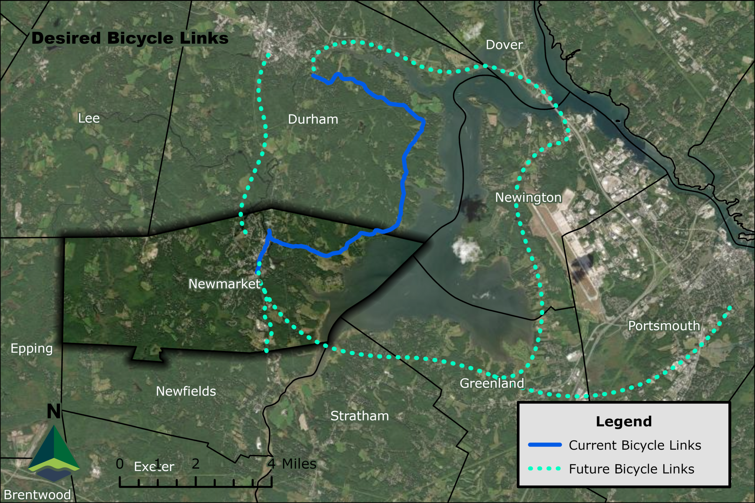
Newmarket’s existing village core is a key part of the community’s identity. Residents enjoy its walkability and regularly walk to the village core from their homes. Residents desire more walkable connections between neighborhoods, between destinations in town, and to neighboring towns. There are many existing trails in town with the potential to be linked. In the 2024 Master Plan survey, the top priorities for connectivity included: a connection between the Rockingham Recreation Trail to downtown Newmarket; an off-road connection between Newmarket and Durham; and an expansion of the existing sidewalk and trail network to close gaps between neighborhoods, parks, and open space.
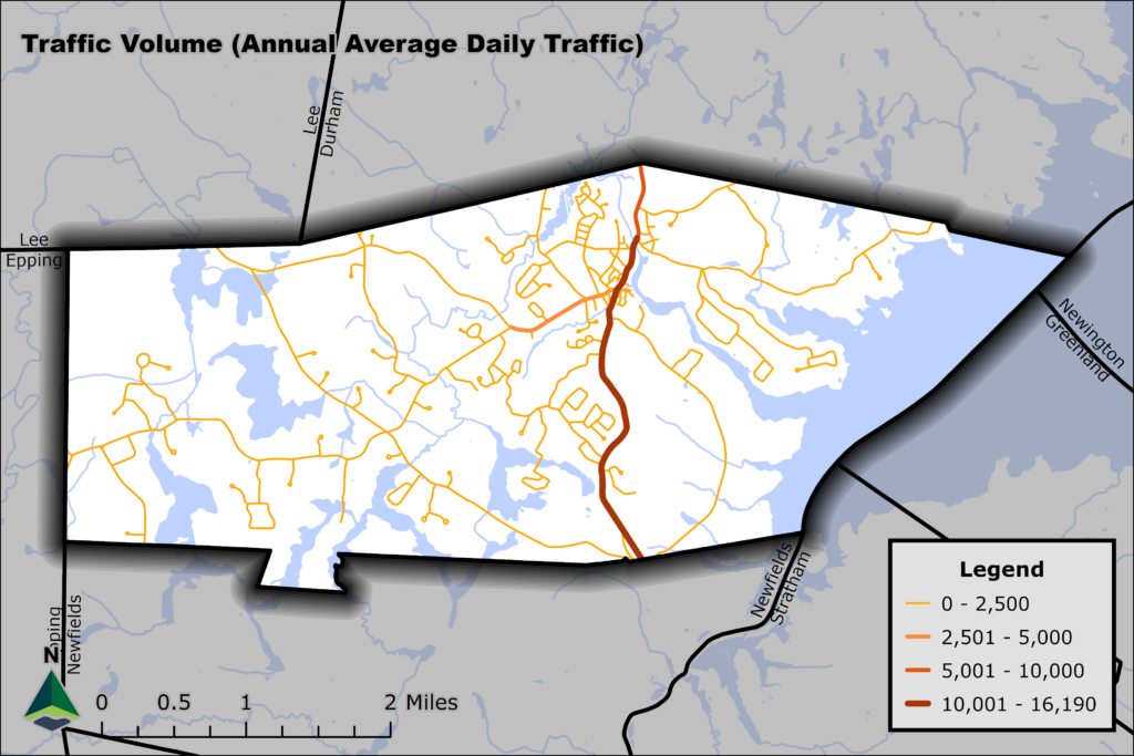
Roads connect people, but they also can be designed to create a sense of place and community. For example, roads should be designed to clearly announce transitions between types of road uses. NH108 and NH152 are the primary routes drawing travelers to town. As travelers near the village core, density and pedestrian activity increase along the road. Road design needs to focus on decreasing vehicle speeds as building density and pedestrian activity increase. This is known as “traffic calming.” There are numerous traffic calming techniques that can reduce traffic speeds at strategic locations along transportation corridors.
Public transportation also connects people; however, Newmarket is currently isolated from the regional public transit network. The Cooperative Alliance for Seacoast Transportation (COAST) operates Route 7 On-Demand which provides service to Exeter and points between. Riders must reserve a ride and designate their destination. There is no longer any connection to the mainline COAST network. The 2024 Master Plan survey included questions about restoring public transit and possible destinations. Newmarket residents prioritized local connections to Portsmouth, Durham and UNH, Exeter, and Dover. Many residents said they would also use public transportation to reach urban areas like Boston, MA and Portland, ME.
Newmarket has an excellent location for a future passenger rail station along the Amtrak Downeaster route. Adding a stop on the Downeaster route will require increased capacity on the existing rails, which will require improvements to the rails outside Newmarket – such as upgrades in Rollinsford and Dover (projects identified by the Northern New England Passenger Rail Authority). A passenger rail stop in Newmarket will require significant levels of collaboration between residents, neighboring communities, and regional partners and CSX (owner of the rail lines) to achieve regional rail investment.
Connectivity Goals
- Improve ability of residents to bike or walk safely within their neighborhoods and to village core from surrounding neighborhoods.
- Ensure safe connectivity and access to destinations within and outside Newmarket.
- Support regional improvements to public transit and community transportation.
- Provide a zoning code and subdivision regulations that facilitate contextual road designs based on land use characteristics.
Accessibility
An accessible community has an environment that is meaningful and usable for as many people as possible.
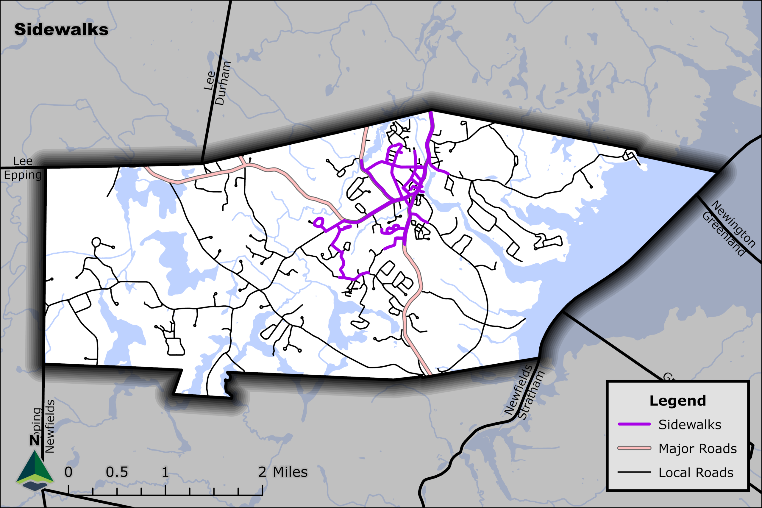
People should be able to get from their homes to their daily destinations safely and efficiently, regardless of income, age, or physical ability. This concept was confirmed as a priority in the 2024 Master Plan survey, where respondents ranked pedestrian safety as the highest transportation priority in Newmarket. Sadly, since 2012, six crashes have occurred in Newmarket that resulted in fatalities (both pedestrians and people in vehicles as reported by the Fatal Accident Reporting System – National Highway Traffic Safety Administration). During the 2024 Master Plan workshop, attendees indicated a high need for additional lit crosswalks town wide.
Over the past 30 years, the Town has made great strides in creating a quaint downtown streetscape with a Main Street that complements the traditional New England mill town – while providing a pedestrian network that promotes a better walking, social, and commercial experience.
Nevertheless, conflicts still exist between pedestrians, cyclists and vehicular traffic in this section of town which have yielded calls for additional safety and infrastructure improvements. Specifically, the siting and circulation of parking along with conflicting interactions between vehicles and pedestrians are cited as a deterrent to both new businesses and for residents and tourists to enjoy and visit the downtown.
Newmarket isn't easy to get to from elsewhere. I suspect many of the patrons are people who live here rather than people visiting from elsewhere. I think building up 108 between the train tracks and the car wash and making that area more vibrant and walkable could help Newmarket grow economically while also serving the hundreds of folks who live on Bennett, Ladyslipper, Sewell, Hersey, etc. An outdoor gathering space, traffic calming, sidewalks/pedestrian infrastructure, shade trees, etc. It's the faster route to downtown from that area, but less pleasant.
2024 Master Plan Survey Respondent
Bicycle and pedestrian access/safety for all of Newmarket. Focus on getting the people safely in to downtown and not have to share the road with cars. Grant [Road], Ash Swamp, and Wadleigh Falls Rd should have connectivity to downtown.
2024 Master Plan Survey Respondent
Fortunately, at the time of the drafting of this Master Plan, the Town of Newmarket and local transportation partners have several efforts underway that are aimed at universal design and safety improvements. Newmarket will be able to look to this effort in planning for its own sections of Route 108 at the “gateway” areas north and south of downtown and is already undergoing zoning changes that would encourage development that complements such transportation alternatives.
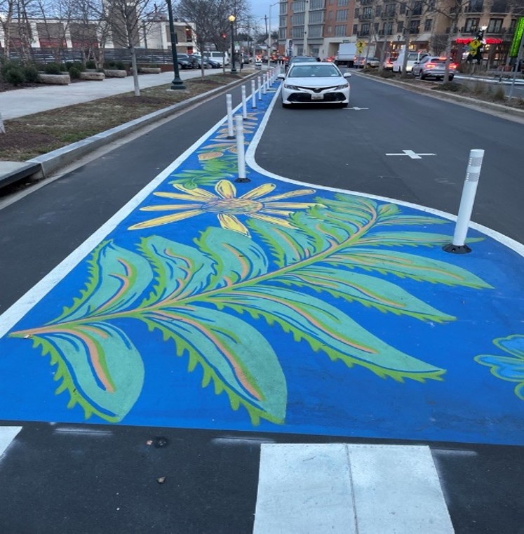
Pictured below is one “complete street” as implemented in a Washington, DC-area suburb. This downtown street features street art, a separated median, and a protected bike lane that retains on-street parking next to local businesses. The street in this example has a daily traffic volume of about 10,000 vehicles, similar to Newmarket’s own Main Street.
Ultimately, town staff and the Public Transportation Advisory Committee will use the Master Plan to develop local guidance for configuring Newmarket’s roads. In tandem with the federal functional classification system and the State of New Hampshire’s legislative and functional classification system, a community may elect to formalize its own road hierarchy. This local guidance will help implement the town’s vision for local roadways by recommending road configurations in specific context.
Neighborhood streets, rural highways, and other travelways will have specific recommendations and will include specific considerations for cyclists, pedestrians, and community amenities such as public art and benches or lighting. The system would provide the town with a vision to refer to in regular maintenance of existing streets (for example, sidewalks or lighting) but also if funding becomes available for more intensive upgrades (for example, lane modifications, addition of bike lanes or transit stops, or implementation of traffic calming). The pedestrian level of stress analysis, regional Complete Streets efforts, and parking study will be used to inform a classification system that is accessible to all users and retains a local vision.
Accessibility Goals:
- Zero crashes that result in fatalities and serious injuries on roads in Newmarket.
- Coordinate priority improvements to safety, streetscape, and parking with scheduled road maintenance.
Affordability
An affordable community is where people can live comfortably without financial difficulty.
Newmarket will suffer if the transportation system is biased toward people who can afford to own and maintain a personal motor vehicle. An affordable transportation system gives people the option to drive, bike, walk, or take public transit. Newmarket and the greater Seacoast’s popularity has posed new cost-of-living challenges. As stated in the Housing Chapter, rents have risen dramatically and this has been identified as one reason both COAST and UNH Wildcat have reduced or cut services to Newmarket as ridership has shrunk. As stated in the Accessibility section above, pedestrian safety was identified as the highest transportation priority in the Master Plan survey. However, for respondents of the 18-24 age group, public transit was ranked the highest priority. None of this group responded “No” to the question “If public transportation was restored in Newmarket, would you or members of your household use it?” However, more research and outreach is needed due to the small sample size of this age group in the survey.
Prior to Summer 2018, COAST’s Route 7 connected Newmarket with shopping and employment in Stratham and Exeter. Now an “on-demand” service, Route 7 remains available to all, and not just groups such as older adults or those experiencing a disability. COAST Route 7 on-demand has no restrictions on destination or reason for travel. However, travel times can be unpredictable, and some local volunteer and non-profit services offer door-to-door service for trips such as doctors’ appointments or are folded into existing services offered to older adults and those experiencing disabilities. In Newmarket, operations such as Ready Rides, Meals on Wheels of Rockingham County, and Community Rides are available via TripLink, the central call center for all or part of Strafford, Rockingham, and Carroll counties that is intended to fill the gaps public transit cannot fulfill. Future in Sight and Granite State Independent Living are options as well, but they are not within the TripLink network (see Appendix C).
Wildcat Transit, the off-campus component of UNH’s bus network, provided service to Newmarket on its Route 5 until May 2023. Ridership was declining even prior to the COVID-19 pandemic. In some months in the early 1990s and again in the mid-2010s, Route 5 carried 5,000 or more trips. March 2020 was the last month where Route 5 carried 1,000 or more trips (see Appendix C)
The ridership of Amtrak’s Downeaster line has shown improvement since the pandemic. The closest stations to Newmarket are the Durham-UNH station on the campus of UNH (a road distance of 5.3 miles from Newmarket Town Hall) or the Exeter station (a road distance of 8 miles, or available on the on-demand Route 7 COAST service). Many Newmarket residents use the Downeaster for leisure, commuting, and as a link to other transit hubs and it was a major topic referenced in the Master Plan survey. The Downeaster’s ridership usually peaks in the summer tourist season, having reached a new monthly high of over 60,000 riders in August 2019, and quickly returned to nearly 58,000 monthly riders in July 2024.
Affordability Goals
- Expand public transportation options.
- Expand electric vehicle charging infrastructure..
Resiliency
A resilient community can withstand, recover or adjust to adversity or change.
A resilient transportation system is critical for effective local response during an emergency, and the recovery from it. Climate change is increasing the likelihood of extreme and damaging weather events. Once-in-a-generation storms are happening more often. Other events also pose a rising threat to the transportation system – such as extended periods of extreme heat that degrade pavement more rapidly. Sea level rise will change the landscape in the Great Bay and the tidal portion of the Lamprey River. Newmarket should identify parts of town where people could be cut off during a storm if part of the transportation network were to fail.
Staying active in the regional climate science and adaptation process is essential for local resiliency. Newmarket participated in the first New Hampshire Coastal Risk and Hazards Commission and should participate in the 2025 update to ensure local and regional climate concerns are represented through updated research and recommendations. In particular, Newmarket is highlighted in the state’s 2016 sea level rise report “Preparing New Hampshire for Projected Storm Surge, Sea-Level Rise, and Extreme Precipitation: Final Report and Rise, and Extreme Precipitation: Final Report and Recommendations” scholars.unh.edu/cgi/viewcontent.cgi?article=1389&context=prep As a coastal community, the Town plays a critical role in a regional decision-making process around climate adaptation.
Newmarket should maintain an up-to-date inventory of local transportation infrastructure and systems that identifies vulnerabilities to various potential damage and disruption. The inventory should identify which culverts and bridges over streams and rivers are most vulnerable to flooding and damage during a heavy rainstorm. Replacing undersized culverts will improve road integrity and safety and build resilience in the local road network.
The transportation network can be used as a resilience asset. Rain needs to be quickly diverted off a road, and it can be diverted into vegetated basins. Transportation infrastructure that incorporates trees and plants can make the streetscape more attractive, safe, and resilient.
In addition to resilience in the built infrastructure, the transportation system should incorporate resilience in the services it provides for the community and those who live in it. A resilient road network should accommodate adaptation if one part of it is incapacitated: are there alternative routes for essential travel patterns? A Newmarket resident may temporarily or permanently loose the ability to drive independently. What transportation options are available for them to continue their daily lives?
Resiliency Goals
- Invest in critical transportation to maintain functionality.
- Increase transportation options for Newmarket residents.
- Keep nature part of downtown experience.
- Incorporate future climate projections into all infrastructure design.
- Lead the energy transition away from fossil fuels.
Appendix
See Appendix C in the appendix document.