Land Use
Vision
Newmarket will plan for future development using sustainable land use practices that protect the Town’s ecological, scenic, and recreational values, and improve economic prosperity. Strategic planning will be used to plan for multi-modal transportation, respond to housing and recreation needs, strengthen the economic base, and create clean energy options while providing opportunities for art, cultural, and historical enjoyment.
Vibrancy
A vibrant community is one that exudes energy and is full of activity and life. It is welcoming and friendly to all ages, supports cultural diversity, and provides economic opportunities.
Newmarket has become a community of great diversity and is rapidly becoming the community that others look to for inspiration for their own communities. It has maintained the New England charm with an historic downtown Main Street while bringing in a compatible mix of new structures for economic development. Part of the success is due to an amicable understanding of what the community needs and wants are, and what the town leaders can do to address these needs and wants.
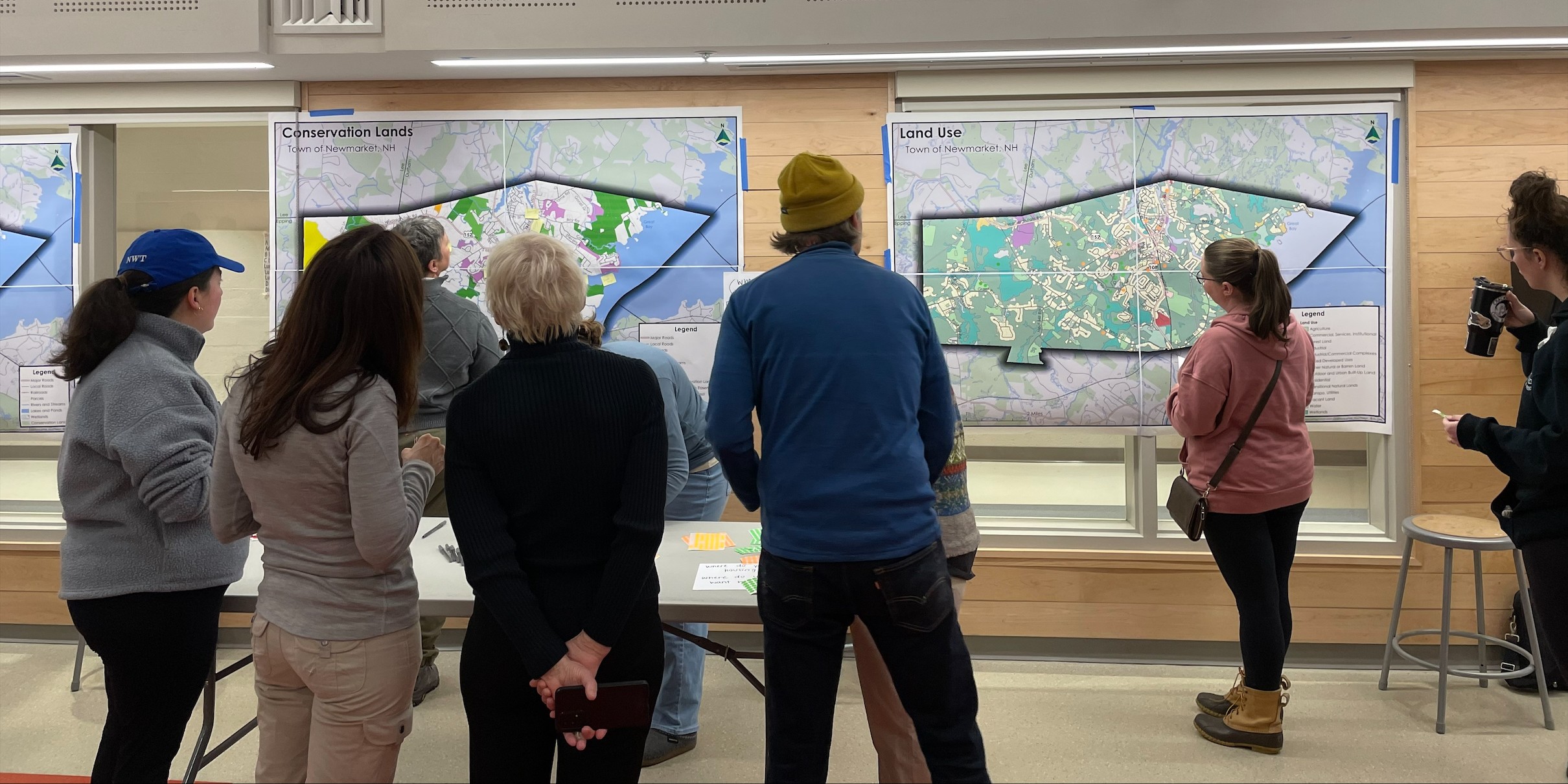
Through the outreach efforts noted above, several common land use themes were identified: more community space to relax and hold community events; additional recreation space; maintain New England downtown feeling; more parking (see also Recreation Chapter, Arts, Culture, and Historic Resources Chapter, and Downtown Riverfront Plan).
Vibrancy Goals
- Increase opportunities to use the downtown as a park area for people to congregate, including well lit, seating, safety, and access to waterfront views.
- Create additional opportunities where people can interact in community spaces.
- Keep aging in place as a priority for residents when building new residences, transportation and infrastructure.
- Support the development and retention of a diverse mix of businesses that reflect Newmarket’s unique character and history, and contribute to a robust, year-round economy.
- Encourage new subdivisions to be planned and built in a way that supports vibrant multi-generational neighborhoods.
Connectivity
The term “connectivity” has many meanings, but when using it in the context of community planning, it means that a connected community has efficient and safe links to daily wants and needs such as between home, jobs, shopping, school and services, and provides welcoming and inclusive public places for social interaction.
Making connections has both a social (non-structural) implication and a physical (structural) implication. The social interactions between residents and visitors vary depending on their interests and level of communication with others. Both non-structural and structural connections are needed to improve the quality of life that we so desire. Maintaining a diversity of “places” to connect with others is important to help people enjoy their free time, gain knowledge, and stay healthy and active. When planning for future needs, projects should aim to be inclusive, affordable, accessible, and well planned for budget efficiency. Some of this may be provided for by the Town budget, while some may be provided by private entities.
Connectivity Goals
- Increase the amount of walkable and bike-able spaces, sidewalks, safe bike lanes, trails, and connections to increase and improve the accessibility to places without relying on automobiles.
- Establish and utilize local and regional transportation solutions to reduce the reliance on vehicle traffic within and through downtown.
- Facilitate neighborhood-based economic development opportunities in other locations to connect residents to their needs within walking/biking range to help reduce trips (vehicle) in the downtown area.
- Install or improve wayfinding to encourage people to use the walkable and bikeable trails throughout Town and connections to places out of town.
Accessibility & Affordability
An accessible community has an environment that is meaningful and usable for as many people as possible. An affordable community is where people can live comfortably without financial difficulty.
Accessibility: How do we get there? This is a question that must be asked to look at accessibility needs. While many may view this as simply a road/transportation issue, it is much more. In planning, it also refers to how well someone can enter and move through buildings, trails, and programs. More recently, accessibility has been an important driver for businesses and potential home buyers when considering moving into Newmarket as it looks at internet access. The ability to access three-phase power is another consideration for businesses.
Building codes follow the Americans with Disabilities Act (ADA) requirements which are easier and more cost efficient if they are followed during construction rather than trying to retrofit them after the building is completed. This is also true during construction of sidewalks and parking lots. Ramps and clear markings (signs and road paintings) not only make things easier and safer for people to access, but it is also the right thing to do.
Affordability: When planning for a diverse and vibrant community, the cost of living in a community is usually the number one priority. To make it more affordable, there must be a variety of housing choices to meet varied incomes and types of living units (see Housing Chapter). Affordability also applies to the cost of needs and wants including decent wages, transportation, entertainment, and nearby services.
Accessibility & Affordability Goals
- Review and enable zoning changes that allow for more access to more diverse housing stock and appropriate scale residential and commercial development.
- Encourage housing to be in closer proximity to community services.
- Promote economic development to bring in new businesses to ease the burden of property taxes in Newmarket.
Accessibility Goals:
- Develop Inclusive Open Spaces – Develop accessible parks and trails and upgrade infrastructure for safe and accessible access to natural and recreational assets.
- Enhance Water Resource Education – Promote outreach and information about conservation, environmental stewardship, and water quality.
- Increase Access to Waterways – Invest in improvements to infrastructure to strengthen recreational use accessibility.
Resiliency
A resilient community can withstand, recover or adjust to adversity or change.
Resiliency, in community planning, refers to the successful recovery of a community during economic shocks and environmental impacts. During the Covid-19 epidemic, Newmarket responded to the economic impact by switching to remote meetings and allowing temporary outdoor seating for restaurants. Today, we have a more diverse workforce as some employers have shifted toward remote workers. It also changed shopping by adding home delivery services for groceries and household goods, and medical services by offering telehealth options.
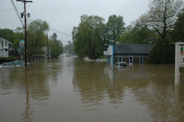
Resiliency of natural disasters can be a challenge depending on the type and severity of weather events. For example, Newmarket’s Hazard Mitigation Plan includes strategies such as replacement and upgrading of culverts and other stormwater management efforts to increase resilience to severe flooding. Finding ways in which the Town and residents react to these weather events saves lives, property, and infrastructure.
Economic resiliency is also important and can be successful by having a diverse economic base. Planning for economic resiliency can be done by making edits to the land use regulations and zoning where needed.
Resiliency Goals
- Continue to refine zoning and land use regulations for sustainable growth: encourage denser development near public infrastructure while preserving open space and sensitive lands for wildlife habitat and flood areas.
- Encourage and promote a diverse economic base by reviewing and refining zoning and land use policies.
- Investigate the feasibility of developing municipal energy sources to maintain resiliency in municipal infrastructure.
- Continue to assess and inventory public infrastructure that supports sustainable land use development and improve the capacity as needed.
- Ensure institutional continuity to achieve Master Plan and other long-term planning and community development objectives.
Future Land Use
Existing Zoning
Land use policies, including zoning, are key mechanisms to implement the future land use vision. Newmarket’s 13 zoning districts each establish granularity and neighborhood distinctions across four major zones: Mixed Use, Business, Residential, and Village Center Districts. As the Town works to amend its zoning through a series of Housing Opportunity Planning (HOP) Grants it continues to place neighborhoods as a central focus, organizing neighborhood conversations to drive change.
Overall, the Town is largely developed and much of the undeveloped land is either in more rural areas or constrained by natural resources. Under current zoning regulations, it is estimated that there are 568 undeveloped lots, and of these approximately 456 are potentially buildable. In terms of the Town’s total acreage, 18,070 acres, 12,030 acres are either developed or constrained in a way that will not allow new development. Most of the potentially buildable land is located within the Rural Residential District.
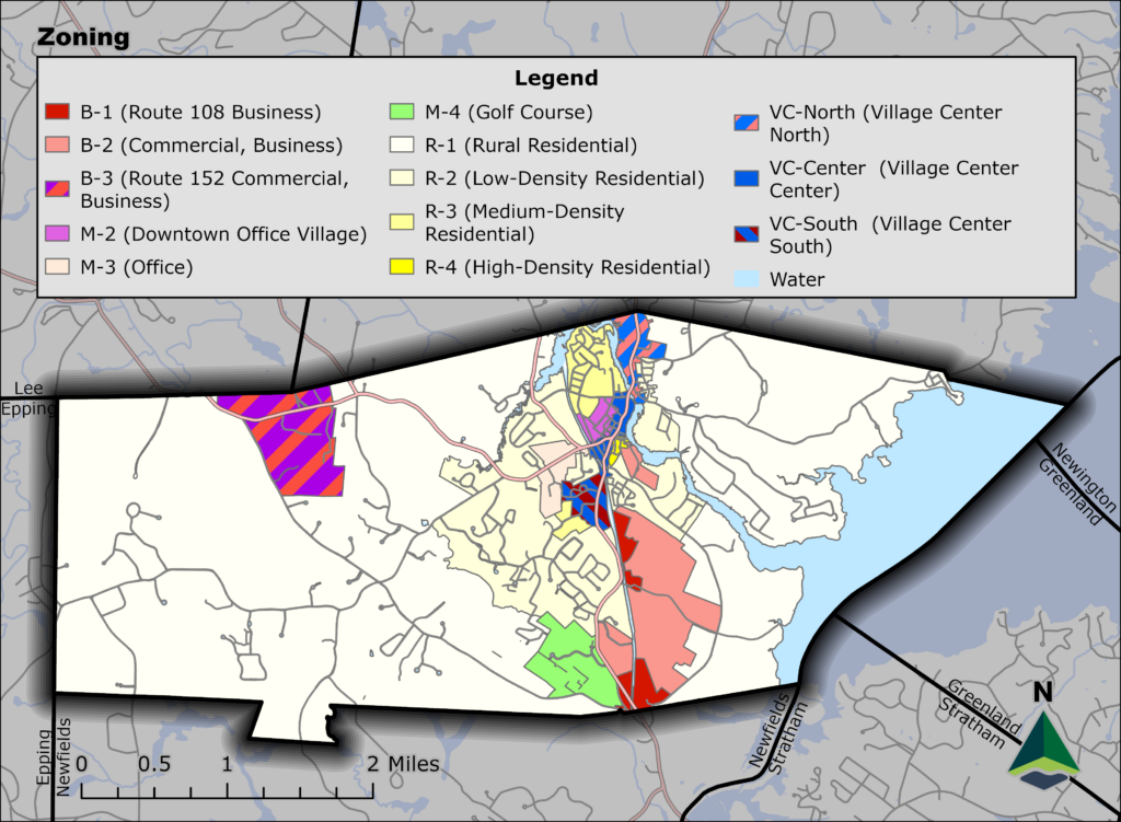
The three Mixed Use Districts are each distinct in character and aim to provide for the ongoing use of the mill buildings, as well as provide for a mix of commercial, social, civic, and residential uses through redevelopment. Given the scarcity of land available and existing development patterns, the district focuses on the enhanced quality of the village, protection of important historic resources, and celebration of the downtown Lamprey River waterfront. While there is limited area for new development, these districts provide a range of redevelopment opportunities that closely align with the town’s Land Use Goals – particularly vibrancy and connectivity goals.
Newmarket’s three Business Districts each aim to create a variety of business, commercial and industrial uses and are the only zoning districts to exclude residential uses. Where the B-1 focuses more on smaller scale retail, office, and restaurants as the typical development type, the B-2 and B-3 allow larger scale development such as warehouses, manufacturing, or conference centers. The business districts aim to both connect residents with their needs and promote economic development to bring in new businesses to ease property taxes for residents. The B-3 district coincides with the proposed West Gateway node and enables the eventual redevelopment of the sand and gravel site.
Most of the buildable lots and acreage within Newmarket are within the Residential Districts. The four residential districts are distinguished by their permitted densities and housing typologies. These districts range from 2-acre minimum lot sizes in the R-1 Rural Residential to 0.25 acres in the R-4 District, with the R-2 and R-3 districts serving as transition zones (0.5-acre minimum lot sizes). Through its second HOP Grant, the town will be reevaluating the residential districts to encourage a variety of housing affordable to residents.
The Village Corridor District continues the traditional development pattern of Main Street on properties along NH Routes 108 and 152 and are divided into three zones: North, Central, and South. These three zones are the most recently established in Newmarket based upon feedback from community conversations. Each is established as a Form Based Code that emphasizes the character of development and is structured around building typologies. Within these zones future applicants are provided with building diagrams that illustrate allowable units, building form, and fenestration. The goal is to create pedestrian friendly redevelopment and infill development.
Refer to Appendix A for a detailed analysis of developable land area in each of the zoning districts.
Future Land Use
Planning for the growth and development of land use requires consideration of existing land use, development constraints, and infrastructure. It also requires a review of demographic trends and projections to ensure that future needs are considered. And finally, an understanding of public sentiment that will drive demand for community spaces, amenities, and services. Newmarket residents place a high value on the protection of conservation and recreation open spaces. While not as highly ranked as open space during the Master Plan Survey, residents also prioritized transportation and renewable energy infrastructure, as well as mixed use development opportunities.
Community feedback, the analysis of current zoning, combined with the articulated goals and objectives from all Master Plan chapters, were used to map a future land use vision for Newmarket. The mapped results reflect points of change or emphasis. These are locations where zoning should be evaluated, land conservation efforts should be targeted, and infrastructure investments planned and implemented.
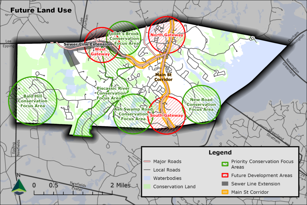
Gateways: Identified as North, West, and South Gateways, these future development areas are situated at the main access points into Newmarket via state highways. The three gateways are envisioned to provide a mix of uses that will achieve the Town’s development priorities for each of the specific areas. The West Gateway provides significant mixed use development opportunities.
Conservation Focus Areas: Important environmentally sensitive and natural resource-rich areas for protection include Follett’s Brook, Bald Hill, Ash Swamp Road, Piscassic River, and New Road to Great Bay Focus Areas. These areas were identified through a data driven process that evaluated the cooccurrence of land and water resources as part of the town’s Open Space Plan.
Main Street Corridor: The Main Street Corridor connects the three Gateway nodes. Transportation infrastructure improvements are rendered more complex given portions of the road are managed by NH Department of Transportation and other segments by the Town and further exacerbated by the railroad crossing at the southern end of Route 108. Need to articulate goals for the Main Street Corridor. The western spur of the Main Street Corridor serves as an additional gateway to the village.
Sewer Line Extension and Infrastructure Investments: A Tax Increment Finance (TIF) District, adopted in conjunction with efforts to spur investment in the West Gateway could help finance the extension of sewer and infrastructure investments needed to make development viable.
Appendix
See Appendix A in the appendix document.